Australian News / 14 April 2023
Cyclone Ilsa gets her destructive on

THE SQUIZ
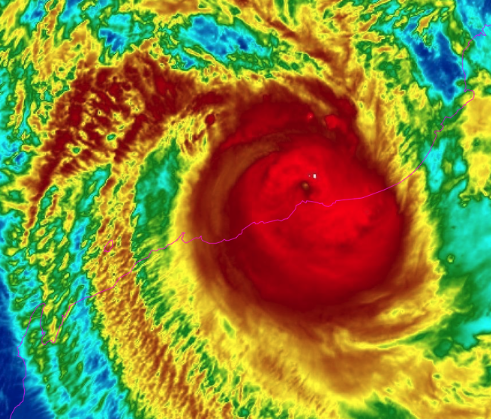
Tropical Cyclone Ilsa made landfall just after midnight local time about 100km east of Port Hedland on Western Australia’s Pilbara coast last night as a category 5 storm, bringing heavy rains and “very destructive” winds. To be exact, it arrived between De Grey and Pardoo Roadhouse, recording wind speeds of up to 274km/h at the centre of the storm. Ilsa was downgraded to a category 4 system almost an hour into its land crossing. The Bureau of Meteorology’s Shenagh Gamble said Ilsa is a “well-behaved” storm that’s followed the forecast tracking map. But with wind gusts of 130km/hour in the region and more than 100mm of rain recorded so far, she said “it’s a pretty hefty system that’s moving through.”
DID THE BOM JUST FAT-SHAME A STORM?
Well, it is a big one… Ilsa has set a new sustained wind speed record of 218km/hour as it passed over a recording station on Bedout Island, off the Pilbara coast. The previous record was Cyclone George’s 194km/hour, which was set in 2007, so the BOM said the last record was “blown away”… Chuckles aside, the experts say Ilsa has brought extremely destructive winds, and it’s not letting up anytime soon. The storm is expected to weaken as it continues but will maintain its structure and intensity. That means cyclonic conditions are expected to impact communities across the Pilbara for days. Local officials say they are prepared to ride the storm out, and the evacuation of hundreds of people from small communities like Bidyadanga to Broome was necessary. Nearly 100 additional first responders were flown into the region, and authorities had started preparing for the clean-up and relief effort ahead of Ilsa’s arrival.
HOW DOES ILSA COMPARE TO PAST CYCLONES?
Ilsa’s right up there as one of the strongest to hit Oz since Cyclone Trevor moved over the Northern Territory and Queensland in 2019. In case you need a reminder of what happened there, Trevor caused the largest mass evacuation of people in the Territory since Cyclone Tracy hit back in 1974. Thankfully, there were no fatalities and no major infrastructure damage. Speaking of Cyclone Tracy, that category 4 storm reached wind speeds of 217km/hour in Darwin before the weather monitoring equipment was destroyed. As for Western Oz, experts say the state’s northwest is the most cyclone-prone region in Oz. That’s because of the Indian Ocean’s high sea surface temperatures and southern hemisphere cyclones moving in south-easterly directions. So there you go…
Know someone who'd be interested in this story? Click to share...
The Squiz Today
Your shortcut to being informed, we've got your news needs covered.
Also Making News
Get the Squiz Today newsletter
Quick, agenda-free news that doesn't take itself too seriously. Get on it.
